


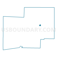
LOUISVILLE E Voting District, Stark County, Ohio
About
Outline

Summary
| Unique Area Identifier | 652014 |
| Name | LOUISVILLE E Voting District |
| County | Stark County |
| State | Ohio |
| Area (square miles) | 0.42 |
| Land Area (square miles) | 0.42 |
| Water Area (square miles) | 0.00 |
| % of Land Area | 100.00 |
| % of Water Area | 0.00 |
| Latitude of the Internal Point | 40.84012480 |
| Longtitude of the Internal Point | -81.24314720 |
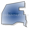
Maps


Graphs
Select a template below for downloading or customizing gragh for LOUISVILLE E Voting District, Stark County, Ohio


Neighbors
Neighoring Voting District (by Name) Neighboring Voting District on the Map
- LOUISVILLE B Voting District, Stark County, OH
- LOUISVILLE D Voting District, Stark County, OH
- LOUISVILLE F Voting District, Stark County, OH
- NIMISHILLEN TWP 4 Voting District, Stark County, OH
- NIMISHILLEN TWP 6 Voting District, Stark County, OH